Prev
Next
Locale: Utah - Uinta Mountains
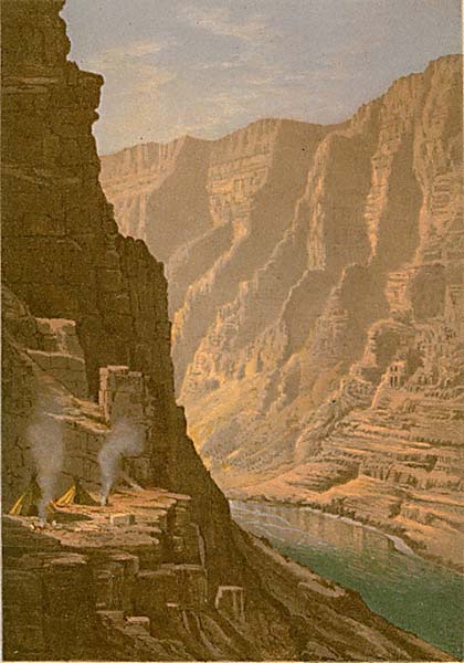
 This chromolithograph is Plate V in Clarence King's Systematic Geology, published in 1878 as part of
the record of the United States Geological Exploration of the 40th Parallel, 1867-1872.
The plate is one of ten based on sketches by Munger, who was a guest artist of the survey.
See this site page for more complete information.
This chromolithograph is Plate V in Clarence King's Systematic Geology, published in 1878 as part of
the record of the United States Geological Exploration of the 40th Parallel, 1867-1872.
The plate is one of ten based on sketches by Munger, who was a guest artist of the survey.
See this site page for more complete information.
Lodore Canyon contains the Green River as it parallels the Utah-Colorado border. The plate depicts the small portion of the canyon that just nudges into Colorado, as claimed in the title.
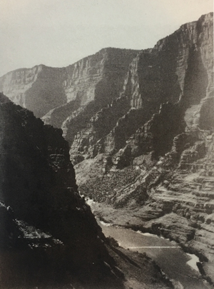
The plate is similar to the King survey photo shown at the right taken by Timothy O'Sullivan in November of 1872. Since we have no documentation that Munger visited Lodore Canyon, some have suggested that Munger made his sketch from the O'Sullivan photo. But you can see that the plate and the photo depict views made from slightly different perspectives. Furthermore, the San Francisco Daily Evening Bulletin article of 1872 Aug 10 describes Munger's sketches of the Green River Gorge, aka, the Canyon of Lodore. QFD Pl.40. Tweed 2003 Exhibition n.37. The image below is a direct scan of the Systematic Geology plate.
Prev Next
#146. Canon of Lodore - Uinta Range - Colorado.
8.5 x 6, chromolithograph. Title on plate.
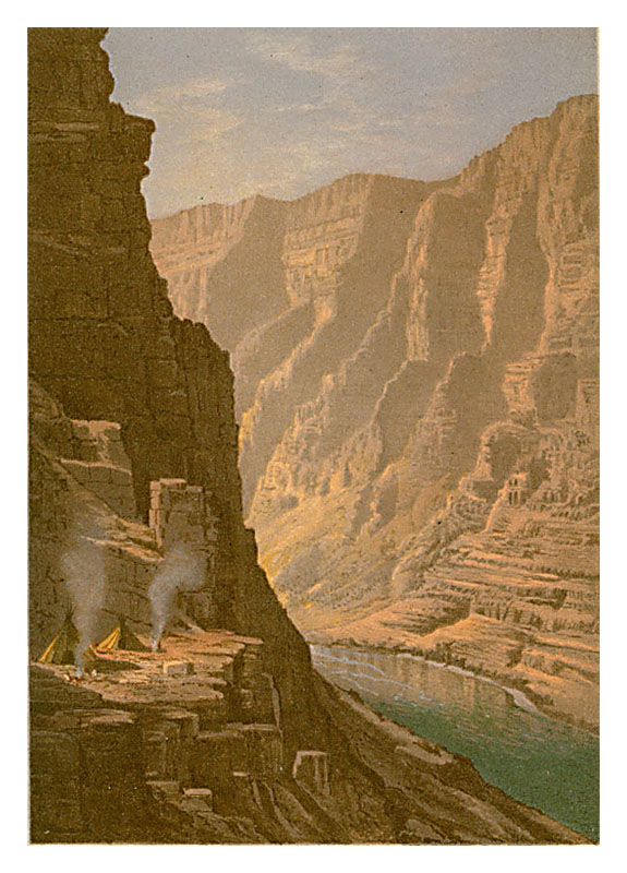
This chromolithograph is Plate V in Clarence King's Systematic Geology, published in 1878 as part of
the record of the United States Geological Exploration of the 40th Parallel, 1867-1872.
The plate is one of ten based on sketches by Munger, who was a guest artist of the survey.
See this site page for more complete information.
Lodore Canyon contains the Green River as it parallels the Utah-Colorado border. The plate depicts the small portion of the canyon that just nudges into Colorado, as claimed in the title.
The plate is similar to the King survey photo shown at the right taken by Timothy O'Sullivan in November of 1872. Since we have no documentation that Munger visited Lodore Canyon, some have suggested that Munger made his sketch from the O'Sullivan photo. But you can see that the plate and the photo depict views made from slightly different perspectives. Furthermore, the San Francisco Daily Evening Bulletin article of 1872 Aug 10 describes Munger's sketches of the Green River Gorge, aka, the Canyon of Lodore. QFD Pl.40. Tweed 2003 Exhibition n.37. The image below is a direct scan of the Systematic Geology plate.
Prev Next
© Michael D. Schroeder 1 Sep 1999; Updated 5 Feb 2023.